- PO Box 1953, Tamworth NSW 2340
- trrra@outlook.com
TAMWORTH REGIONAL RESIDENTS & RATEPAYERS ASSOCATION
Supporting the residents and ratepayers in the Tamworth Regional area.
TAMWORTH REGIONAL RESIDENTS & RATEPAYERS ASSOCIATION
Supporting the residents and ratepayers in the Tamworth Regional area.
TAMWORTH REGIONAL RESIDENTS & RATEPAYERS ASSOCIATON
Supporting the residents and ratepayers in the Tamworth Regional area.
TAMWORTH REGIONAL RESIDENTS & RATEPAYERS ASSOCIATION
Supporting the residents and ratepayers in the Tamworth Regional area.
Our Mission
To support residents and ratepayers within the Tamworth Regional Council area with regional and local government issues.
Our Meetings
TRRRA meets on the third Wednesday of each month, except January. Meetings start at 6:00pm people can attend in person at Tamworth City Bowling Club, cnr. Napier and Brisbane Streets, Tamworth or via Zoom.
Join TRRRA
Membership is free and is available to residents and ratepayers of the Tamworth Council Region.
Tamworth Regional Residents and Ratepayers Association
Tamworth Regional Residents and Ratepayers Association (TRRRA) aims to to support the residents and ratepayers who live within the Tamworth Regional Council (TRC) local government area with local government issues.
TRRRA meets on the third Wednesday of each month, with the exception of January commencing at 6:00pm at Tamworth City Bowling Club, cnr. Napier and Brisbane Streets, Tamworth or via Zoom..
The purpose of our meetings is to obtain and provide information as well as facilitate discussion. Depending on the issue, the TRRRA may also advocate on behalf of the community regarding local government issues relating to the TRC.
We encourage all residents and ratepayers within the TRC local government area to attend our meetings and to raise any concerns they may have regarding the TRC and local government issues.
TRRRA Meeting Calendar
| Jan | Feb | Mar | Apr | May | Jun | Jul | Aug | Sep | Oct | Nov | Dec |
|---|---|---|---|---|---|---|---|---|---|---|---|
| 19/02 | 19/03 | 16/04 | 21/05 | 18/06 | 17/07 | 21/08 | 18/09 | 16/10 | 20/11 | 18/12 | |
| AGM/ Meeting |
Current Projects
Letter to the Editor – 21.02.2024
•
February 21, 2024
Ray Walsh House (RWH) has had $2 million spent on removal of all the internal walls and floor coverings. We are told by a reliable informant that the asbestos lagging around the air conditioning above the false ceilings is still in place. We have also been told that all of the fittings in the Tamworth Regional Council (TRC) Chambers and meeting room on the fourth floor, many being historical artefacts, have been removed and disposed of as waste, as have all of the floor coverings throughout the building. Essentially the interior of RWH has been gutted. The source of the original asbestos issue does not appear to have been addressed.
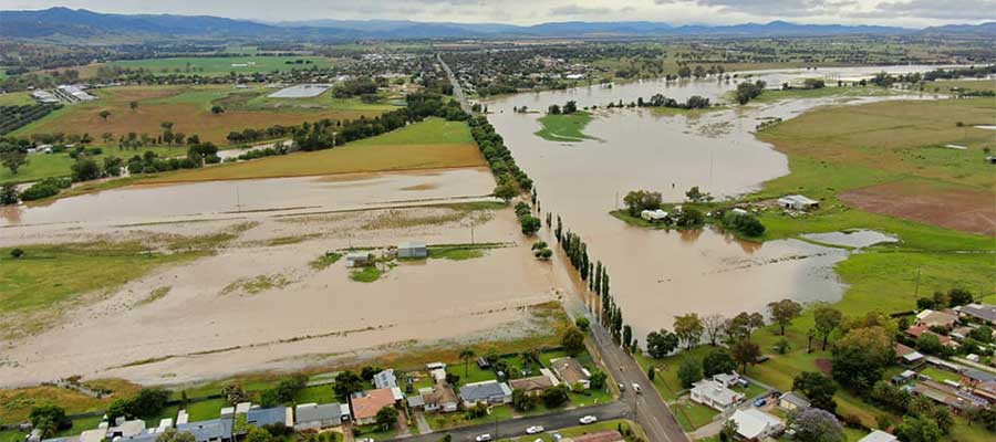
Calala Alternative Access
•
November 22, 2021
Currently, during flooding, access to Calala is complete cut off, which leaves the residents of Calala without access to emergency services. As an organisation, the Tamworth
Past Projects
2023 Special Rate Variation
•
October 25, 2023
Tamworth Region Says No – Community Campaign This is the official campaign in opposition of the proposed rate hike in Tamworth LGA. This website is a work in progress and will be “filled out” over the coming days.
Long Term Water Security
•
July 14, 2016
Contents Murray-Darling Basin Authority Independant Pricing & Regulatory Tribunal Tamworth Regional Council Media Releases Northern Daily Leader Extracts TRRRA Facebook Extracts Water planning in our region must be comprehensive and integrated to ensure long-term security. Until now water
Proposals for King George V Avenue
•
June 14, 2016
Contents Extracts from TRRRA Facebook page Northern Daily Leader Extracts Tamworth Regional Council Media Reports Tamworth Regional Council Business Papers and Minutes The trees on King George Avenue are again under threat with the Council seeking a report
Tamworth Regional Council
The Tamworth Regional Council area is located in the New England Region of New South Wales, about 410 kilometres north-west of Sydney and 580 kilometres south of Brisbane. There are approximately 60,998 people living within the TRC area, which covers 9,893 Km2.
The Tamworth Regional Council area stretches from the Nandewar Range north of Barraba, to the head of the Peel River and the Great Dividing Range. Surrounded by Gwydir Shire in the north, Uralla Shire and the Walcha Council area in the east, Upper Hunter Shire in the south, and Liverpool Plains, Gunnedah and Narrabri Shires in the west.
The Tamworth Regional Council area encompasses the suburbs, towns, villages and rural localities of Appleby, Attunga, Banoon, Barraba (part), Barry, Bective, Bendemeer, Bithramere, Borah Creek, Bowling Alley Point, Bundarra (part), Calala, Crawney (part), Daruka, Duncans Creek, Dungowan, Duri, East Tamworth, Garoo, Garthowen, Gidley, Goonoo Goonoo, Gowrie, Gulf Creek (part), Halls Creek, Hallsville, Hanging Rock, Hillvue, Ironbark, Kentucky (part), Kingswood, Klori, Kootingal, Limbri, Lindesay, Longarm, Loomberah, Manilla, Mayvale, Moonbi, Moore Creek, Mulla Creek, Namoi River, Nemingha, New Mexico, Niangala (part), North Tamworth, Nundle, Ogunbil, Oxley Vale, Piallamore, Red Hill, Retreat, Rushes Creek, Somerton, South Tamworth, Taminda, Tamworth, Thirloene, Timbumburi, Tintinhull, Upper Horton (part), Upper Manilla, Wallamore, Warrabah, Warral, Watsons Creek, Weabonga, West Tamworth, Westdale, Wimborne, Winton, Wongo Creek, Woodsreef, Woolbrook (part) and Woolomin.
Sources:
Demographic resources
Tamworth Regional Council Community Profile
Tamworth Regional Council Atlas


